0
pyqt5のアプリケーションでqmlを使用していて、マップグリッドをマップに追加したいとします。しかし、どこから始めたらいいのかわかりません。それで、もしそれを作ることさえ可能ですか?そうであれば、小さな事例がありますか?これは私のmap.qmlです。qmlにマップグリッドを作成することはできますか?
import QtQuick 2.0
import QtQuick.Controls 2.2
import QtQuick.Window 2.0
import QtLocation 5.9
import QtPositioning 5.5


Item {
id: myItem

Plugin {
    id: mapPlugin
    name: "mapboxgl"
}

Map {
    id: map
    objectName: "mapboxgl"
    property double lat: 47.368649
    property double lon: 8.5391825
    visible: true
    anchors.fill: parent
    plugin: mapPlugin
    center {
     latitude: lat
     longitude: lon
    }
    zoomLevel: 14

    ListView {
     height: 1
     model: map
     delegate: Text {
      text: "Latitude: " + (center.latitude).toFixed(3) + " Longitude: " + (center.longitude).toFixed(3)
      }
     }

     MouseArea{
      id: mouseArea
      property var positionRoot: map.toCoordinate(Qt.point(mouseX, mouseY))
      anchors.fill: parent
      onClicked: {
        var component = Qt.createComponent("addAttribute.qml")
        if (component.status === Component.Ready) {
        var dialog = component.createObject(parent,{popupType: 1})
        dialog.sqlPosition = positionRoot
        dialog.show()
       }
      }
     }

    MapQuickItem {
     id: marker
     objectName: "marker"
     visible: false
     anchorPoint.x: 0.5 * image.width
     anchorPoint.y: image.height
     sourceItem: Image {
      id: image
      source: "icons/markerIcon.png"
      MouseArea{
       anchors.fill: parent
       onClicked: {
        ToolTip.timeout = 2000
        ToolTip.visible = true
        ToolTip.text = qsTr("Coordinates: %1, %2").arg(marker.coordinate.latitude).arg(marker.coordinate.longitude)
       }
      }
     }
    }

    MapItemView {
     model: markerModel
     delegate: MapQuickItem{
      anchorPoint: Qt.point(2.5, 2.5)
      coordinate: QtPositioning.coordinate(markerPosition.x, markerPosition.y)
      zoomLevel: 0
      sourceItem: Column{
        Image {
         id: imag
         source: "icons/markerIcon.png"
         MouseArea{
          anchors.fill: parent
          onClicked: {

           ToolTip.timeout = 2000
           ToolTip.visible = true
           ToolTip.text = qsTr("Coordinates: %1, %2".arg(markerPosition.x).arg(markerPosition.y))
          }
         }
        }

        Text {
         text: markerTitle
         font.bold: true
        }
      }
     }
    }
    MapParameter {
    type: "source"
    property var name: "coordinates"
    property var sourceType: "geojson"
    property var data: '{ "type": "FeatureCollection", "features": \
     [{ "type": "Feature", "properties": {}, "geometry": { \
     "type": "LineString", "coordinates": [[ 8.541484, \
     47.366850 ], [8.542171, 47.370018],[8.545561, 47.369233]]}}]}'
    }

    MapParameter {
     type: "layer"
     property var name: "layer"
     property var layerType: "line"
     property var source: "coordinates"
     property var before: "road-label-small"
    }

    MapParameter {
     objectName: "paint"
     type: "paint"
     property var layer: "layer"
     property var lineColor: "black"
     property var lineWidth: 8.0
    }

    MapParameter {
     type: "layout"
     property var layer: "layer"
     property var lineJoin: "round"
     property var lineCap: "round"
    }
}
}
グリッドはこのように見えます。 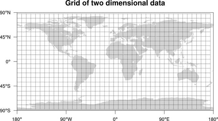

以下のようにCanvasを使用し、グリッドを描画する:おそらくはい。おそらく削除するには、より多くの情報が必要です。あなたがすでに持っているものをいくつか提供してください*あなたが好きなマップグリッド*の種類をもっと詳しく説明できますか?たぶん、あなたはそれが今見ている方法とそれがどのように見えるべきかを示すいくつかのイメージを追加することができます。 (*さらに詳細な機能の説明に加えて) – derM
私の 'qml'コードとグリッドがどのように見えるかのイメージを追加しました。現時点では私はグリッドを持っていません。なぜ私が1つを作ることができるか分からないからです。だから私のグリッドのイメージはありません。 – Blinxen